There are numerous hikes in Death Valley National park that create an excellent opportunity for seeing some of the park’s best attractions by foot.
With the exception of a few high elevation hikes, many of these are best done from late fall to early spring as temperatures during the summertime are too extreme for hiking at lower elevations.
Here are 10 of the best hiking trails in Death Valley National Park.
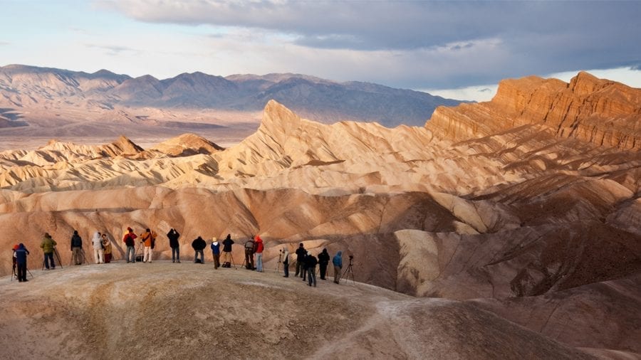
Zabriskie Point Trail
- Length : 0.3 miles
- Difficulty : Easy
- Estimated Time : 1 hour
- Best Time : October
You can’t come to Death Valley National Park without visiting Zabriskie Point Trail, which offers the spectacular desert views that are iconic of the park. And, given its very short length, you can make this trek easily.
This short paved path leads to an overlook with a 360º view of the surrounding terrain, including Manly Beacon and Red Cathedral, two rock formations characteristic of the park that tower over the parks’ hills and valleys.
If you really want to maximize the experience of this hike, time your visit for either sunrise or sunset, which will afford you spectacular oranges and pinks. This hike is located about 5 miles southeast of Furnace Creek. If you go in the summer, plan your trip early as it can get scorchingly hot in the middle of the day.
Badwater Basin Crossing
- Length : 6.5 miles
- Difficulty : Moderate
- Estimated Time : 3 hours
- Best Time : January
This is one of the park’s iconic hikes as it takes place at 282-feet below sea level, the lowest point in North America. The first section is well worn and easy to follow as it is the most popular stretch. Most people; however, get there after about a half-mile and turn back. The rest of the way is rugged and can be difficult to follow, so a good map is essential.
You can see for miles in all directions, so you’re unlikely to get lost, but there are also few landmarks to help navigate. The trail comes to its end at West Side Road where you’ll want to arrange for a shuttle, or you’ll have to make the long trek back.
This hike is beautiful for its stark desolation. Once you get past the busy section, you can enjoy the zen-like feel of total solitude. Just make sure you choose the best time to take this hike, especially during the summertime when temperatures reach well above 100ºF. A hydration pack is highly recommended for this trek.
Desolation Canyon Trail
- Length : 3.7 miles
- Difficulty : Moderate
- Estimated Time : 2 hours
- Best Time : February
If you don’t mind the isolation and have faith in your ability to navigate rugged trails that’s not always obvious to follow, then take on the Desolation Canyon Trail. This 3.7-mile out and back hike follows a washed out trail through the ravine.
This ravine leads to a wilderness area amidst the Black Mountains. The main draw here is the nearby Artist’s Palette. As you head deeper into the Ravine, the colors for which the area is known to become more and more prominent as you make your way through the peaks.
You’ll be treated to red, yellow, purple, and green rock formations created from the oxidation of the rocks in these mountains. There’s also a tremendous view of the Death Valley and the Panamint Range of mountains.
Telescope Peak Trail
- Length : 12 miles
- Difficulty : Hard
- Estimated Time : 8 hours
- Best Time : July
For serious hikers only, Telescope Peak presents a tough high-altitude hike to the top of Telescope Peak. The hike offers a very different feel than what Death Valley is known for, as it takes you through forests of pine trees and junipers with an elevation that reaches more than 11,000 feet above sea level.
Whereas the basin features extremely high temperatures, when hiking Telescope Peak, you’ll need to be prepared for high elevation exposure and inclement weather. Snow and freezing temperatures are a very real possibility as you reach higher elevations. Rain gear and cold weather jackets are a must for hiking at this elevation.
From the trailhead to peak, you’ll bag more than 3,000 feet of elevation, so make sure you have a good pair of hiking boots. The reward at the top is stunning views of the surrounding mountains that are beyond compare.
Darwin Falls
- Length : 2 miles
- Difficulty : Easy
- Estimated Time : 2 to 3 hours
- Best Time : September
This hike seems oddly out of place in Death Valley. That’s because the year-round waterfall doesn’t really jive with the California Desert that is most associated with this national park.
Less than a mile into this hike, you enter a collection of cottonwoods and willow trees that seem lush and almost rain-forest like in comparison to the surrounding harsh and lifeless desert. The trail only seems more out of place as it goes on with numerous creek crossings before culminating with a 20-foot waterfall, which looks strikingly out of place.
The waterfall includes plenty of shade and is buzzing with wildlife in the form of bars, frogs, and insects. As much as you may be tempted to swim here, swimming is prohibited as the creek is a water source.
Ubehebe Crater Loop
- Length : 1.8 miles
- Difficulty : Moderate
- Estimated Time : 1 to 2 hours
- Best Time : November
With its 600-foot depth and measuring almost a half-mile across, this crater is a can’t-miss attraction inside Death Valley National Park. The loop that circles this crater is the best way to experience it. This relatively easy hike allows for excellent views of the crater’s interior.
There are also plenty of side trails for viewing such sites as the cinder fields, which are colorful rock layers in the crater’s eastern wall. These cinders are as much as 150 feet thick on the crater’s rim.
And, if the loop isn’t challenging enough for you, venture down into the crater via a short 0.3-mile hike on Ubehebe Crater Floor Trail. Just keep in mind that this is a steep trail, which makes the climb out, though short, quite difficult.
Mosaic Canyon
- Length : 2 miles
- Difficulty : Easy
- Estimated Time : 2 to 3 hours
- Best Time : October
A hike through Mosaic Canyon leads into ever-narrowing slot canyons with exposed marble and breccia. The pattern this mix of rock creates gives the canyons its mosaic name.
Start this hike at Stovepipe Wells. There’s no marked trail, but the path is easy to follow through the well-trodden wash. Eventually, the wash gives way to rock which turns into the narrow slot canyons. The walls of these canyons are remarkably smooth, thanks to all the loose stone and sediment that passes through them during flash floods.
You can follow this path for about 2 miles before it becomes impassable and you’ll need to turn back. If you choose to do this hike, check the weather first as flooding can make this hike extremely dangerous.
Salt Creek Interpretive Trail
- Length : 1 mile
- Difficulty : Easy
- Estimated Time : 1 hour
- Best Time : April
This easy boardwalk trail skirts Salt Creek, which only flows through Badwater Basin during the winter and spring months. This is an excellent place to look for pupfish, which only live in Death Valley National Park.
These remarkable fish plant eggs into the bed of the creek, which endure the heat of the summer and fall before hatching with the arrival of water to the creek in the winter.
There are plenty of signs along this route that provide plenty of information about these fish and other wildlife and plants in the and around the creek. The best time to actually view the fish is in the spring when their population is highest. This trail is located about 13 miles northwest of Furnace Creek.
Mesquite Flat Sand Dunes
- Length : 4 miles
- Difficulty : Moderate
- Estimated Time : 2 hours
- Best Time : January
There aren’t any trails that carve through Mesquite Flat Sand Dunes. Given the nature of the shifting sands, that would be impossible. However, this is absolutely a must-do hike in the park if you come at a time of year when it’s doable. This desert section is one of the iconic parts of Death Valley National Park.
Hike to the highest dune, which is about 100 feet tall. The trek there is about 2 miles and will take you about 1.5 hours to get to the tallest dune and back. This is significant because you don’t want to get caught out in the middle of the day.
This is a hike best done in the park’s cooler winter months. Make sure to bring a large water bottle or, better yet, wear a hydration pack.
Golden Canyon/Badlands/Gower Gulch
- Length : 7.5 miles
- Difficulty : Moderate
- Estimated Time : 3 to 4 hours
- Best Time : January
This loop features a little bit of everything, including views of Red Cathedral Cliffs, Zabriskie Point, and Manly Beacon. This hike offers moderate terrain with less than 1,000 feet of climbing; however, you’ll be treated to tremendous views.
This is one of the top long hikes in the park and is located just a few miles from the Visitor’s Center on Golden Canyon Road.
Though this route can be started from either Golden Canyon or Zabriskie Point, the Golden Canyon start point offers the best vantage point for Red Cathedral and it ends the hike on a downhill. The route begins with a gradual uphill through Golden canyon before reaching Red Cathedral. You’ll arrive at Zabriskie Point before descending into the badlands.

Andrew Dodson
Andrew Dodson is an avid camper who enjoys the great outdoors with his wife and two-year-old son. He resides in Colorado, where you can often find him enjoying hikes with a toddler strapped to his back and mini goldendoodle Percy nearby.